Click on the images to see the full resolution.
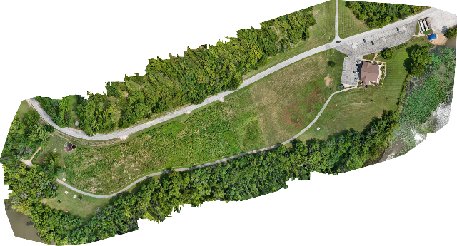

One flight. Hundreds of images. One incredibly detailed map.
Orthomosaic Mapping
Your Property. One Accurate, High-Resolution Map.
Traditional aerial photographs capture a moment. An orthomosaic combines hundreds—or even thousands—of drone images into one seamless, distortion-corrected map of your property.
The result is a highly detailed overhead image that can be zoomed in to inspect individual features while maintaining an accurate view of the entire site.
Whether you're managing a construction project, documenting land conditions, or planning future development, an orthomosaic provides information that ordinary photographs simply can't.
Applications
Construction Progress
Document projects from groundbreaking through completion with consistent aerial records.
Commercial Property
Create current site maps for planning, maintenance, insurance documentation, and property management.
Agriculture
Monitor crop conditions, drainage patterns, field boundaries, and land improvements.
Parks & Recreation
Maintain accurate maps of trails, facilities, parking areas, athletic fields, and natural resources.
Real Estate
Showcase large properties with an overhead perspective that buyers immediately understand.
Infrastructure
Document roads, parking lots, utilities, and public facilities for maintenance and planning.
Benefits
Distortion-corrected aerial mapping
Extremely high-resolution imagery
Zoom in without losing clarity
Measure distances and areas
Document existing site conditions
Compare changes over time
Excellent for reports, planning, and presentations
Easy to share with engineers, contractors, architects, and stakeholders
Why Choose Ozark Sky Imaging?
Every orthomosaic is produced using FAA-certified drone operations and professional photogrammetry software. Our workflow captures hundreds of overlapping images that are processed into a single, seamless map with exceptional detail and consistency.
Whether your property is a single commercial building or hundreds of acres, we deliver imagery that helps you see the complete picture.
Important Notice
Orthomosaic maps are intended for planning, documentation, inspection, and visualization purposes. They are not legal land surveys and should not be used to establish property boundaries or legal elevations.
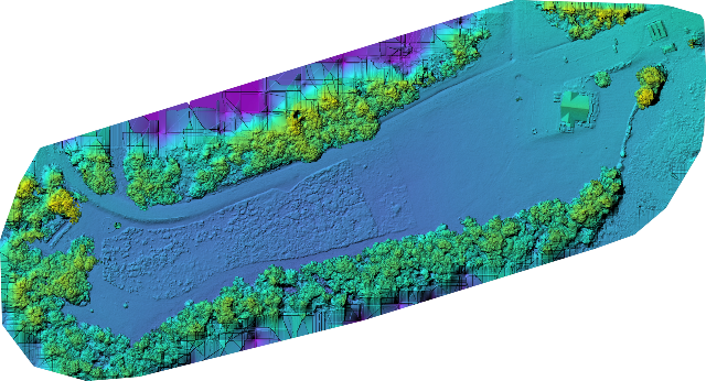
Beyond photography. Elevation you can measure.
Digital Surface Models (DSM)
See your property in a whole new dimension.
A Digital Surface Model (DSM) transforms hundreds of aerial photographs into a highly detailed 3D elevation map. Every tree, building, roadway, and change in terrain is represented with precise height information, giving property owners and professionals insights that traditional photographs simply cannot provide.
A DSM can help you:
Identify drainage patterns and water flow
Locate low spots where water may collect
Measure slopes and grades
Monitor erosion over time
Plan construction and site development
Evaluate stormwater management
Estimate stockpile or excavation volumes
Document existing site conditions before construction
Support engineering and environmental projects
Ideal for
Commercial developments
Construction sites
Farms and ranches
Municipal infrastructure
Industrial facilities
Parks and recreation areas
Large residential properties
At Ozark Sky Imaging, we combine FAA-certified drone operations with advanced photogrammetry software to create accurate, high-resolution elevation models that help you make informed decisions. Whether you're planning a project, documenting existing conditions, or monitoring changes over time, a DSM provides valuable data you can trust.